 Slovenski INSPIRE metapodatkovni sistem
Keyword
topography, settlements, roads, names, relief, hydrography, maps, traffic network, imagery/base maps/land cover
1 record(s)
Type of resources
Categories
INSPIRE themes
Keywords
Contact for the resource
Scale
-
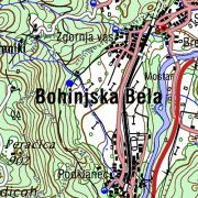
The territory of Republic of Slovenia covers 58 sheets of the National Topographic Map at 1 : 50 000 scale. Raster images with DTK 50 sheets are provided. Besides the joined color layer also eight geolocated raster layers are provided: - settlements, communications, names - border of roads and rocks - roads in relation to road surface, traffic surfaces - relief - contour lines - water - vegetation - UTM network - relief shadows. From year 2017 the map is available also as seamless cartographic raster layer. Georeferenced raster image is written in TIFF + TFW files in resolution 4 m (317.5 dpi) and cut into 99 rectangle tiles in 9 rows and 11 columns. DTK 50 is intended for spatial planning, for orientation on the field, as base for other themes, as a source for making other maps. Raster and vector data are available as free data.